by Madeline Kernan
 |
| The boundary of Olympic National Park along the Deer Park Road is clear cut (pun intended!). Well, technically this is not a clear cut, although to the untrained eye, it is hard to know the difference. This "new forestry"style cut in the Washington DNR land (right side of photo) has actually left some trees standing as a way to more quickly regenerate second growth forest with complex structure that most wildlife prefers. Note the national park sign is riddled with bullet holes--an expression of discontent with the ownership of the land behind it? |
When I got to the parking lot of Wallace Hall on Saturday
morning, the couple of students who knew each other were chatting, a few people
were getting supplies out of Tim’s office, and a few more of us (like me) were
standing around, not quite sure what to do with ourselves. Most people seemed
to have stayed up late packing and were more than a little shocked that the
trip had come up so fast. Something had gone wrong with one of our van reservations,
so our TA, Kramer, went back to his house to grab his truck. However, we were
soon on the move and headed toward our ferry. I rode in the UW van (which we
would later return to Seattle, looking deeply unofficial, as though we had
borrowed it to drive through a swamp) with Tim, Jacob, Emi, Minji, Abby, Kate,
and Kelly. Emi was sitting on the floor between Abby and Minji for a bit of the
ride, before she migrated to Kramer’s truck, where the little seat between the
driver’s and passenger’s found an inhabitant. Jacob helped navigate us to the downtown Seattle ferry terminal, and when we got onboard, everyone got out of the cars for our first
discussion of the trip. We stood on the deck, huddled together a bit as the
cool morning breezes blew on our rain jackets. Tim talked to us about the glacial history of the Puget Sound, and the landing of the Denny Party (and encounter with Chief Sealth) at Alki Beach on a rainy November day in 1851, marking the beginnings of the urban metropolis we were now leaving behind. [Interestingly, Arthur Denny proclaimed the place "as
wild a spot as any on earth"(www.historylink.org). The oldgrowth forest
of Schmitz Park rising above Alki condos is the only visible connection
to the original landscape.]
When we got to the Peninsula we made a stop in the town of
Jamestown, the home of the S’Klallam tribe, and read the informational display
that overlooks the bay. Before the trip we had read some articles and papers
about the pre-colonial inhabitants of the Olympic Peninsula and their impact on the landscape. We acknowledged that we would be spending the week hiking the S'Klallam homeland, and that the concept of "wilderness" as we know it today, would have been meaningless to pre-colonial Native Americans. This visit
connected the theoretical and historical way our society looks at Native
Americans with modern realities.
 |
| Jacob studies some of the excellent interpretive displays at the Jamestown S'Klallam reservation, this display documenting the many plants that the S'Klallam traditionally used. Other displays talk about the history of the S'Klallam people and their land. |
We also made a snack stop for those of us who had skipped
breakfast, and for the person, who will remain unnamed, who didn’t know they
had to bring a lunch. At the Olympic National Park Wilderness Information Center, we squashed our
food into our borrowed bear cans (designed to keep bears from getting human food, thereby keeping them wild), and then squashed the bear cans into our
packs. With lots of sitting on top of backpacks, shaking, pushing, and pulling,
and tying things to the outside, everyone’s backpacks were ready to go. I was
trying to figure out if there was anything I could leave behind in the car, as I
had finally realized that the “46” embroidered on the outside of my pack meant
that it was 46 liters (as compared to the 65-70 , the recommended size). At the
REI garage sale, I had thought that was, like, the model name or something.
 |
| Kramer, demonstrating how to pack a pack, before we all loaded up. We made the decision to pack at the WIC because it would likely be raining at our high elevation trailhead. |
Before we left the center, a park ranger named Molly Travis
came to talk to us about park management and goals. She spoke about the park’s
concern with “opportunities for solitude,” and how quotas for some popular areas
of the parks maintain the park’s peaceful and “wild” atmosphere, but conversely,
by applying that quota, the site is seen as even more desirable and receives
more visitors. As those sites grow more popular by word of mouth, equally beautiful
and interesting, but less trendy sites remain less visited.
 |
| The National Park Service is mandated to preserve the wilderness resource, while at the same time allowing people to "enjoy" it--sometimes these goals conflict. In an interesting nuance to the preservation mandate, Ranger Molly Travis talks about how the Wilderness Information Center manages the land for "solitude" by imposing visitation quotas on certain areas. Paradoxically, she pointed out that quotas tend to make quota areas even more popular! She views herself primarily as an educator, rather than an enforcer of rules. |
After we left the Wilderness Information Center, we drove
outside of the park to reach a different entrance to get to our hike-in spot.
Tim decided that our bear cans weren’t quite full enough, so he and Kramer ran
into a store to buy more noodles. As we approached the entrance to the park,
Tim pointed out the clear line of smaller trees right where the park ended and
logging was permitted. He also hopped out of the car to take a picture of the
sign for the park, which had a few bullet holes through it (see photo at beginning of this post).
 |
| Heavy rain and dense clouds as we ascend to Deer Park. Thankfully we ascended through the clouds and into clearer weather at the top. |
It was misty in this part of the park and as we drove along
the narrow road, occasionally another car would come zipping around the bend
and I made myself carsick imagining the van rolling over and over down the
steep hill. We made a final stop up high on a ridge, where we looked at the
alpine plants growing in the tundra-like environment of the hillside. It was
surprisingly cold outside, but after the hot car and windy road, no one was
complaining. We took a few pictures of the clouds clinging to the mountains and rare Rocky Mountain juniper on the hill.
 |
| Rocky Mountain Juniper, a rare plant in the northeastern Olympics, and more common in the San Juan Islands. It is thought that this mountain top, in the northeast corner of the Olympics was ice-free in the last ice age, serving as a refuge for Rocky Mountain Juniper, which then dispersed into the San Juans as the Puget Lobe retreated. As its name suggests, it is more common east of the Cascades and in the Rockies. |
 |
| Comparing the foliage of the Common Juniper to Rocky Mountain Juniper. |
 |
| Astragalus cottonii, Cotton's Milkvetch, one of the rarest endemic plants in the Olympic Mountains, and a state listed threatened species, eking out a living near the junipers above. It is one of the hardest hit by non-native Mountain Goats. Near here we also found the remains of an old cable left from an era
when a small ski resort was on this mountain--the Park Service's mandate
to provide "enjoyment" while simultaneously preserving the landscape, has now tipped
more towards preservation--perhaps rightfully so given the fragility of this environment. |
Soon we were all at the camping site where we would leave
the cars. We helped each other get our backpacks on. It was like a small child
was clinging to my back, but with some strap tightening, I felt top-heavy, but
not overwhelmed.
 |
| Hiking down through the large burn caused by an out of control campfire in the 1980s. One of the species favored by this fire was the Lodgepole Pine. It is interesting to see it taking over what was once a Douglas fir/Subalpine fir dominated area. Lodgepole Pine has cones glued shut by sticky pitch, which pop open and release their seeds when heated. |
Our first hike of the trip was three or four miles down
switchbacks into a valley. We had our pack flies and garbage bags securely on
against the mist. Though I don’t think anyone could really get too exhausted
since we were going down a hill, I had never known how tired your thighs can
get when they carry an extra fifty pounds down 3000 feet. Tim stopped us to
look at the different kinds of trees, and to show us places where different
plants had met different fates, but as the afternoon passed to early evening we
began hustling a little. I kept an eye on how everyone else was using their
trekking poles – keeping the left and right pole with their respective feet, or
swinging them around as a pair?
We eventually got to our campsite. As we were only a few
hours from the road, there were a few other people there: two women, a mother
and daughter, and a small group of boy scouts who arrived after us, and graciously camped at another site across the river from us.
 |
| Lodgepole Pine saplings coming in to this burn site (see caption above). More frequent burns, and a shift towards Lodgepole Pine forest is likely to occur in the next 50 to 100 years based on the predictions of climate models. |
Kelly and I tried to figure out our REI tent, which was not
particularly symmetrical or intuitive to set up. Rain was falling as we flipped
it around this way and that and looked at the tent instructions, trying to
decide where the poles went. We eventually got it sorted out and went to find
Lucas, who was the third member of our food group, to figure out dinner. As I
was going back and forth from our camp stove to the tent to find my Tupperware and
head lamp, the two women, Heidi and Danielle, invited us to come hang out by
their campfire after dinner. As this was one of the only days we would be at an
approved elevation for campfires, and it was chilly and misty, Tim was happy to
have our discussion at their campfire. At the campfire, Tim talked to us about
the Civilian Conservation Corps (CCC) shelter that was built almost hidden
under the tall, wet trees. Apparently people used to camp inside it before tent
technology was as transportable and waterproof. We went around the circle to
each say a little something about ourselves and Heidi and Danielle, who were
visiting the Northwest, but lived in Mexico, told us about their house which
was made of recycled and found materials, and which they had built to have as
light of an impact on its surroundings as possible. As we talked, I got so
sleepy that I found myself closing my eyes when whoever was speaking was far
away (so hopefully people wouldn’t be looking in my direction.) Tim sent us to
our tents with a wake up time of 8 am, which was only alarming in that Tim described
this as “sleeping in.”
 |
| Campfire in front of the shelter built by CCC boys (hired by the US Forest Service before Olympic was a national park) in the early 1930s. In this small clearing, created by the felling of trees to build this CCC camp, it was not hard to understand the oppressive feeling early settlers must have felt from the forest, as they sat in
small damp clearings in the darkness. For us, in this little clearing in the forested canyon of the Grand River, 3000 feet of elevation below the trailhead, it felt like we had finally arrived in wilderness after a long day of travel and logistics. |
Reflection on my experience and the importance of wilderness:
In the nine days we were outside, I went to bed and got up
earlier than I would ever have chosen to do on my own. The exercise and fresh
air kept me, a champion napper, awake in the day, and the lack of artificial
light sent me straight to sleep at night. Hailee led a discussion toward the
end of the trip about the effects of time outside on mental health, which was
good timing, because I had been outside long enough to reflect more on the
potential ways the outside had affected me, and how it could help other people.
Obviously, backpacking cannot cure all ills, but I found that I never had time
to feel mopey or bored. Being busy all day with walking and chatting and
looking at plants was a simple and effective way to separate myself from my
usual thoughts, and worries and stresses.
Leaving the park, though, I was both relieved to be around flushing
toilets and stovetops that would never be pressing into my back all day. It had
been a long time since I had appreciated sleeping in a bed, that had cotton
sheets and that I wouldn’t have to immediately break down and roll up in the
morning. But at the same time on that car ride, I had a bit of a cynical old
person perspective on technology, at least for an hour or two, before I wanted
to check my messages.
But for one sunny hour, as we drove home, dirty, and bruisey,
and all scratched up, but alive (and swoll, if you will) I would look at the
powered down phone in my lap and, like an octogenarian or something, wonder why
all the young folks are always sticking their noses in their little screens.
Then, when I saw the texts from my friends and family and the news that had
happened in our absence I remembered how it is to feel connected to everyone
you like, no matter how far away they are physically.
I think that a lot of the American conception of wilderness
is deeply twisted and problematic. For a few: our insistence that a landscape
be empty of other humans to be “pure,” that we’re interested in the earth being
“pure” at all, that indigenous people are often reduced to myths, legends, and
improving stories of how to live in balance with nature, instead of living,
breathing people who have been excluded from their previous homes by the
existence of national parks, and federal power in general. I left with a feeling of simplicity, as if I
had figured out that life is not that complicated, but all the while I know that
living a life that is spent in a rural area or mostly outdoors is not a
signifier of an easy, trouble-free life, and as Kelly pointed out in her
discussion, it doesn’t feel like a fun adventure to be forced into wild areas.
For better or worse, national parks are, to some degree, an
artifice. Though at one time those plants and animals would have been there
anyway, in Washington state, the reason those old growth forests and owls are
there is because we wanted a place to hide, to look for opportunities for
solitude, to recreate away from the bright city lights. We buy park passes and
pay taxes to keep our national parks looking as though we aren’t there at all.
While I loved sitting on the mountain top ridges and counting the rings on the
tree stumps, we hadn’t walked into a time before modern life, but the intentional
creation of the colonized, settler America we live in.
 |
| Olympic Onion |
 |
| We sacrificed one from a healthy population off-trail, for educational purposes, and made sure to incorporate it into dinner. |
 |
| More imagery from the 1980s Deer Park fire. |
 |
| Rocky Mountain Juniper, close up. It can be confused with Yellow Cedar, which also can grow above treeline. The foliage looks more like that of Redcedar, however. |
 |
| Pinesap, a mycoheterotrophic plant (no chlorophyll, parasite on soil fungi), growing in the dark shade of dense forest recovering from the Deer Park fire. |
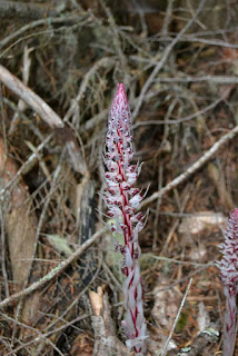 |
| Candystripe, another mycoheterotrophic plant (no chlorophyll, parasite on soil
fungi), growing in the dark shade of dense forest recovering from the
Deer Park fire. |
 |
| Bark of the yew tree, a species that is unusually common on the lower section of trail approaching Three Forks. |


